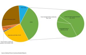
We start off big. Canada, after all, is the second-largest country in the world. But to define the extent of its forest lands, we first need to remove all the water: the lakes, the rivers, and the streams that together make up almost nine per cent of the country.
Next to go is the large expansive non-forested tundra of the Arctic (26 per cent). Followed by the wetlands, swamps, areas of slow-growing and scattered trees (four per cent), and the treed portions of farms, parks and gardens, trees planted around buildings, and plantations like fruit orchards (one per cent). And finally, there’s a big chunk of other non-forested land that must be removed from the equation too: the 25 per cent of Canada that’s used to grow agricultural crops, plus the land we ourselves occupy: the communities, towns and cities where we live. All told, some 65 per cent of Canada is what is called ‘non-forested.’

What’s left is technically known as Canada’s ‘forest lands’: 347 million hectares of forest land divided into 12 distinct terrestrial ecozones, the largest being the Boreal Shield at 131 million hectares, ranging down to the smallest, the Prairies, at one million hectares.
But the shrinking doesn’t stop there. More than one-third of that forest land (122 million hectares) is unmanaged or left in a wilderness state. Which means that the area left for commercial forestry (the harvesting for lumber and wood pulp) is just under 23 per cent of the total. That’s not the end of the story either, since only a tiny portion of that 23 per cent is logged, as we shall see.
(Excerpt from Deforestation in Canada and Other Fake News. Copyright © 2018 by John Mullinder. Reproduced with permission).
